What You See on an Iceland Glacier Hike, Feature by Feature
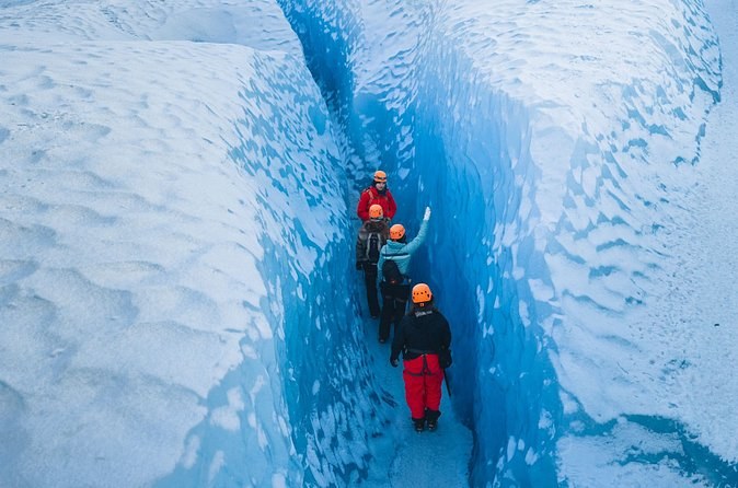
The short answer. On a guided hike you walk from the moraine at the snout onto grey, ash-streaked ice, then up among ridges, meltwater channels, crevasses and moulins, with blue ice wherever the surface is fresh. Each has a reason, and knowing it turns a walk into a lesson. Choosing a glacier hike tour Iceland starts with knowing what you want to see.
How the ice you stand on was made
A glacier is mostly old snow. Where more snow falls in a year than melts, the buried layers are packed tighter and tighter until they turn to firn and then to ice. That ice is so heavy it flows downhill, in the park’s words like dough or molten metal, until it reaches a height where melting wins. On southern Vatnajökull that line sits at about 1,000 to 1,200 metres. Every hike you can book happens below it, on the melting part of the glacier, which is why the surface is hard ice rather than snow.
| Feature | Where you meet it | What to look for |
|---|---|---|
| Moraine and gravel | The walk in to the snout | Scratched rock and gravel ridges |
| Ash-streaked ice | The first slopes of the tongue | Dark bands in grey ice |
| Meltwater channels | Anywhere the surface is melting | Smooth runnels of water |
| Crevasses | Where the ice is stretched | Cracks, seen from a safe edge |
| Moulins | Where streams drop into the ice | A vertical shaft, often roped |
| Blue ice | Fresh faces and ice caves | Ice with few air bubbles |
The moraine at the snout
Your hike starts before the ice. Glaciers carry rock and gravel on top, inside and underneath, and drop it at their edges as moraines: the grey ridges of stone you cross on the way in. The rocks frozen into the base also scrape the bedrock and leave lines called striations. On the three-hour hike near Skaftafell, Taana_V walked about 20 minutes from the parking before the ice began.
Ash in the ice
Iceland’s glaciers sit on volcanoes, and the ice keeps the evidence. Sólheimajökull, an outlet of Mýrdalsjökull, shows it plainly: Terri_G describes a dusting of volcanic ash that made the ice come alive. On Vatnajökull, Heather_H saw volcanic ash trapped in the ice of a cave. The dark bands are old eruptions, laid down as snow and carried downhill for years.
Meltwater channels and glacial milk
On a warm day the surface runs with water. Small streams carve smooth channels into the ice and gather into faster ones. At the snout the water leaves the glacier as a river, cloudy with fine sediment; the park calls it glacial milk. Those rivers shift their course so often that the longest bridge in Iceland, over the Skeiðará, was taken down after the river moved away from it in 2009.
Crevasses
A crevasse is a crack that opens where the ice is stretched as it flows. Some run a few metres, some for kilometres. The weight of the ice limits most to about 30 metres deep, because below that the ice is squeezed shut; but water pouring into a crack can wedge it far deeper. Many are hidden under snow and show up in late summer, which is why you only walk them with a guide. On the longer Explorer hike, Naufa_C jumped over smaller crevasses with a guide’s help.
Moulins
A moulin is a vertical shaft where a surface stream drops into the glacier. Some reach the bed of the glacier. They are the most dramatic thing on a hike and the most dangerous, so guides show them from a safe edge or on a rope. On the Explorer, Mark_M strapped in and peered down into one. The walls of a moulin are often the bluest ice you will see.
Why the ice is blue
Ice absorbs red and yellow light and reflects blue. Snow looks white because the air between the flakes reflects every colour; the more air bubbles in ice, the whiter it looks. So a fresh face with few bubbles glows blue, and so does the inside of a cave. The gallery shows the difference between surface ice and cave ice.
Ice caves, in the cold months
An ice cave is a tunnel melted by water running under or through the glacier. They form and collapse with the seasons, and the park treats any ice under a roof, overhanging or leaning as very dangerous at the end of summer. Cave tours run in the cold months, roughly October to April, and the operator confirms each day. Some caves are small: Anthony_V found a few carved steps and a space for about four people. Heather_H saw volcanic ash trapped in the ice. The calendar by activity explains the timing.
Icefalls and steep ground
Where a glacier pours over a steep step in the rock, it breaks into a jumble of towers and blocks called an icefall. Falljökull is the classic one near Skaftafell: a creeping glacier that tumbles from the caldera of Öræfajökull, whose rim stands about 1,800 metres up. The short hikes stay well below the icefalls; the longer ones climb closer. On the Explorer, Colleen_C spent four and a half to five hours on the ice and got closer to the icefalls than the shorter tours go.
Lagoons at the snout
Many outlet glaciers now end in water. As a glacier thins and retreats, small pools form between the moraine and the ice, merge into a lake, and the lake speeds the melting: the front floats up, breaks and calves. The park points to the lagoons in front of Svínafellsjökull and Skaftafellsjökull as examples of lakes at that stage. The largest of all is Jökulsárlón, where you can ride among the icebergs rather than walk.
Hidden things most hikers walk past
- Striations on the rock by the snout, scratched by stones frozen into the ice.
- Kettle holes on the S1 trail at Skaftafell, left where blocks of ice melted out of the moraine.
- The lagoon at the snout. Lakes form in the hollow a glacier leaves as it retreats, and they speed the melting.
- Old ice-front lines. Moraine ridges further out mark where the ice stood when the glaciers were at their biggest, only about 130 years ago.
Photographs on the ice
You can photograph everything, but keep one hand free on steep ice and put your phone away when the guide is roping a section. Blue ice is strongest on fresh faces and inside a cave. The weather page shows the sunniest months, and the visitor guide covers the gear and the fees.
How the time on a hike is spent
Expect the ice to take less of the day than the name suggests. On the three-hour hike near Skaftafell, Pahul_M counted about an hour to reach the ice and gear up, an hour on it and an hour back. On the five-hour Explorer, Colleen_C spent four and a half to five hours on the glacier itself. If moulins and icefalls are what you came for, the extra hours are where they are.
The order to see it all
Choose the glacier first. Sólheimajökull is best for ash and for a day from Reykjavík; the Skaftafell outlets for icefalls, crevasses and moulins; the lagoon for calving ice and icebergs. The lagoon page covers the water. If you want the features in one day without a car, the South Coast day walks the ash ice. If you want the moulins and crevasses, book the longer hike.
Tours that walk you through all of it
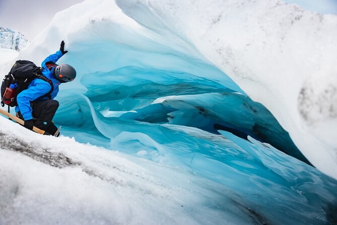
Skaftafell Glacier Explorer - Extended Small Group Trek
Five hours and about 8 km on an outlet glacier of Öræfajökull, with a 4x4 bus to the foot of the ice and the full set of glacier gear; from age 14.
From $168 per person
Check Availability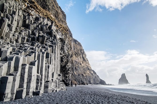
Glacier Hike and South Coast Small-Group Tour from Reykjavik
Twelve hours from a Reykjavík bus stop in a minibus of 18 at most, with a guided hike on the ice between two waterfalls and a black beach; from age 8.
From $197 per person
Check Availability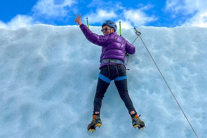
Skaftafell Ice Climbing & Glacier Hike
Four hours with a certified guide, hiking boots, harness, helmet, axe and crampons, and a first go at climbing a wall of ice; from age 12.
From $256 per person
Check AvailabilityNext: read the numbers behind the ice in fourteen things the ice does not tell you. Every fare sits side by side on Iceland Glacier Tours.